222
222
tv
eye 222
favorite 0
quote 0
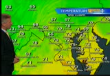
much of maryland, much of virginia into west virginia and western maryland with the peak autumn color now. temperatures have dipped into the upper 40s to just near 50 degrees. storm team 4, four-day forecast, a delightful friday. low humidity in place. afternoon highs climbing to the low 80s with lots of sun. then increasing clouds on saturday. during the afternoon, might be a brief passing shower. highs reaching mid-70s. and then the big change saturday night into sunday when much chiller air moves in. chilly rain off and on during the day sunday. from the morning into the afternoon. sunshine back and cold in the morning on monday as well as on tuesday. afternoon highs chilly. only in the low 60s to mid-60s. a bit warmer midweek with maybe some rain. danella, how's our traffic? >>> right now i'm following the commute as you travel along i-270 southbound from frederick. usual delays starting at about 85, you are slow as you head towards 109. heavy on the brakes in this area. as you continue southbound, though, through germantown, you are seeing volume. not bad at all. travel lanes are
much of maryland, much of virginia into west virginia and western maryland with the peak autumn color now. temperatures have dipped into the upper 40s to just near 50 degrees. storm team 4, four-day forecast, a delightful friday. low humidity in place. afternoon highs climbing to the low 80s with lots of sun. then increasing clouds on saturday. during the afternoon, might be a brief passing shower. highs reaching mid-70s. and then the big change saturday night into sunday when much chiller air...
162
162
Oct 31, 2012
10/12
by
WMAR
tv
eye 162
favorite 0
quote 0
in western maryland a very different story. they're actually shoveling a lot. >> up there three feet of snow in some places. this is what it looks like in garrett county. plow trucks out in full force, trying to clear the snow from the roads. things got so bad tuesday a 50- mile stretch of interstate 68 had to be shut down. that stranded truckers and drivers for a number of hours. road foreman mark wells had had to cut back 50 to 60 trees just to get to work. >> it's treacherous, the trees were falling behind me as fast as i was cutting them out in front of me. i've seen a lot of snow up here, but not from a hurricane. >> power outages in that area because of the wet snow, it's breaking the tree limbs. a blizzard warning continues through today. so they definitely have a mess on their hands. >>> one more check of that forecast with lynette, and before we call it a day on this wednesday, and like you say there, in western maryland, they're telling a completely different story. >> exactly. you can actually behind me some of the w
in western maryland a very different story. they're actually shoveling a lot. >> up there three feet of snow in some places. this is what it looks like in garrett county. plow trucks out in full force, trying to clear the snow from the roads. things got so bad tuesday a 50- mile stretch of interstate 68 had to be shut down. that stranded truckers and drivers for a number of hours. road foreman mark wells had had to cut back 50 to 60 trees just to get to work. >> it's treacherous,...
245
245
Oct 29, 2012
10/12
by
WBAL
tv
eye 245
favorite 0
quote 0
we expect blizzard warnings for western maryland. they will get from 10 to 12 inches of snow in garrett county with these winds. forecast today. heavy rain at times, gusts 20 to 30 morning and 40 to 60 miles an hour this evening as it is closer. two to eight inches of rain. there will be flooding problems. 50's. tomorrow the high 47 and could be snow in the mountains and could be a few flakes around baltimore. that is incredible to say snow when you talk about a tropical system. halloween i will say 40% chance of left yourself showers with a high -- leftover showers and then quiet going in the weekend. it is 5:23. let's see what is happening on the roads. shouldn't be anybody on the roads. >> not a lot in the way of volume. many folks are just staying home a good idea. we are still dealing with just rain but once in becomes stronger out there the winds pick up and we will be dealing with a lot of additional issues, downed trees and power lines expected as the storm comes in. southbound 95 just past mountain road one accident in harfo
we expect blizzard warnings for western maryland. they will get from 10 to 12 inches of snow in garrett county with these winds. forecast today. heavy rain at times, gusts 20 to 30 morning and 40 to 60 miles an hour this evening as it is closer. two to eight inches of rain. there will be flooding problems. 50's. tomorrow the high 47 and could be snow in the mountains and could be a few flakes around baltimore. that is incredible to say snow when you talk about a tropical system. halloween i...
156
156
Oct 31, 2012
10/12
by
WMAR
tv
eye 156
favorite 0
quote 0
we still have the snow in western maryland and also in west virginia, so we have some ski lovers, they can head that way. but here at home today, it's halloween. >> halloween, and it's chilly. it looks like halloween out there. >> exactly. it is spooky. a good word for you. as we check out what's going on on maryland's most werful radar right now, not a whole lot to be found, but if you are going to be traveling back off toward the west, this is where we are looking at a few rain drops across the area, so hagerstown, martinsburg and also a little bit of snow mixing in across that area as well. but things are starting to get back to normal as we go through today, and some kids do have school, so this forecast is just for you. as you head out to that bus stop, we are dealing with some very cold temperatures, so make sure you do bundle the kids up, coming in right around 39 degrees, and even as we go through the afternoon, that temperature only 52. it's going to be chilly, even when you come home, have the coats this morning, and as we go into the afternoon. let's get a check now of the a
we still have the snow in western maryland and also in west virginia, so we have some ski lovers, they can head that way. but here at home today, it's halloween. >> halloween, and it's chilly. it looks like halloween out there. >> exactly. it is spooky. a good word for you. as we check out what's going on on maryland's most werful radar right now, not a whole lot to be found, but if you are going to be traveling back off toward the west, this is where we are looking at a few rain...
231
231
Oct 27, 2012
10/12
by
WBAL
tv
eye 231
favorite 0
quote 0
even some snow in western maryland. i will talk more about in a few minutes. >> right now is the time to prepare for a storm like hurricane sandy, a residence in maryland are gathering everything they need. >> door is live in cells -- fells point. >> we are one of three locations in flooding area. another big threat with storms like these are power outages. for many people, the question tonight is where can i find a generator? >> wow. >> susan is like millions of us on the east coast this weekend. stocking up for sandy. >> plenty of canned food. tour licht paper. t paper. i did want to be prepared. there are a lot of unknowns. >> we are sold out of those right now. like this home depot in townsend -- towson about this its almostut of thought of generators. storm depot has activated its emergency shipment procedures and baltimore area stores should have more than the stock by early saturday morning. >> by 6:00 a.m., all the stores in our district to have the generators. the emergency shipments will keep flowing from arou
even some snow in western maryland. i will talk more about in a few minutes. >> right now is the time to prepare for a storm like hurricane sandy, a residence in maryland are gathering everything they need. >> door is live in cells -- fells point. >> we are one of three locations in flooding area. another big threat with storms like these are power outages. for many people, the question tonight is where can i find a generator? >> wow. >> susan is like millions of...
133
133
Oct 30, 2012
10/12
by
WMAR
tv
eye 133
favorite 0
quote 0
we have snow back across western maryland, also in to west virginia, they could be rereceiving 2-3 feet. we dealt with five inches yesterday. that will continue as we go throughout the day. not only will we have the rain piling up, but the winds as well. these are the current winds sustained about 9 shady side. haverly grace 17. winds gusts are a lot more and those are your tropical storm forced wind gusts we are dealing with. 66 frederick. that's the big one, 48 shady side. we are looking at 46 fredericksburg. haverly grace 36. 53 ocean city. that's what we have to deal with today. see the 71 cape may. before i cover it up. this is in store. rain, wind, and these were the peak wind gusts yesterday. annapolis 69. 68 dundalk, arbutus. bwi60. we are in store for what we had yesterday. more rain and wind. now a check of the time saver traffic with loren cook. good morning. >>> good morning, the mta suspended all operations again today and as lynette mentioned, wind is a big factor, leading to power outages, fallen lines shut down route 24 at route 136. more problems throughout the region,
we have snow back across western maryland, also in to west virginia, they could be rereceiving 2-3 feet. we dealt with five inches yesterday. that will continue as we go throughout the day. not only will we have the rain piling up, but the winds as well. these are the current winds sustained about 9 shady side. haverly grace 17. winds gusts are a lot more and those are your tropical storm forced wind gusts we are dealing with. 66 frederick. that's the big one, 48 shady side. we are looking at...
183
183
Oct 16, 2012
10/12
by
WBAL
tv
eye 183
favorite 0
quote 0
the cool air is locked into western maryland bounds. they have been catching some cloud cover blowing in off the great lakes and now that is diminishing. it will be clear for the rest of the night for most areas. sunset at 6:25. the area of high pressure that brought the beautiful fall conditions today moose off the coast tomorrow. temperatures will start coming up a little bit and the front to the west starts to approach, bringing the next train chance thursday afternoon or evening. 66-71 degrees with son up at 7:19. waves around 1 foot and a water temperatures gradually cooling off a little bit. in western maryland there is a rain chance but it does not get there until thursday. 54 with the showers on thursday. on the eastern shore down to cambridge, 7's 4 highs. showers on thursday probably not until after sunset. nice fall weather with highs in the seven's. we are watching hurricane raphael out near bermuda. kind of a threat to bermuda. they are getting some squalling whether there, tropical storm force winds. the center of the stor
the cool air is locked into western maryland bounds. they have been catching some cloud cover blowing in off the great lakes and now that is diminishing. it will be clear for the rest of the night for most areas. sunset at 6:25. the area of high pressure that brought the beautiful fall conditions today moose off the coast tomorrow. temperatures will start coming up a little bit and the front to the west starts to approach, bringing the next train chance thursday afternoon or evening. 66-71...
177
177
Oct 20, 2012
10/12
by
WBAL
tv
eye 177
favorite 0
quote 0
that cool air is beginning to invade western maryland. frost bird is down to 42 degrees. -- frostburg is down to 42 degrees. this front that triggered the storms is just about out of here, moving toward the coast and getting off shore. behind it, an area of low pressure in the upper midwest is headed for new england. but we will get screwed by the southern edge of this. so there is a chance of a sharp market -- but we will get scraped by the southern edge of this. so there's a chance of a shower. western maryland, showers in the forecast could the storm is lifting out of the great lakes toward new england. western maryland is a little closer to it with scattered showers. then dry weather on sunday. in eastern shore, the rain and snow tonight. the lower eastern shore, 70 degrees tomorrow and cooler on sunday. a weekend of cool, dry fall whether kim highs in the 60's and lows in to the 40's. then we are into the mid-70's for the middle of next week. >> one jain cancellation, but those who played, worth the wait. >> it is friday october 19 a
that cool air is beginning to invade western maryland. frost bird is down to 42 degrees. -- frostburg is down to 42 degrees. this front that triggered the storms is just about out of here, moving toward the coast and getting off shore. behind it, an area of low pressure in the upper midwest is headed for new england. but we will get screwed by the southern edge of this. so there is a chance of a sharp market -- but we will get scraped by the southern edge of this. so there's a chance of a...
132
132
Oct 15, 2012
10/12
by
WJLA
tv
eye 132
favorite 0
quote 0
it will start across western maryland and then move across the metro area by the afternoon. we may see some strong earth thunderstorms by later in the afternoon into the early evening hours across the delmarva peninsula. nighttime lows fall into the 50's. waking up tomorrow morning should not be a problem, but grab your umbrellas. temperatures in the upper 60's to lower 70's of around the pentagon location. to the west, cooler temperatures. to the east, milder temperatures with a southerly wind. thursday, at hamburg -- look for temperatures to drop on tuesday. 64 degrees in town, cooler to the west. near 70 on wednesday. lower 70's on thursday and a chance for showers on friday. i hope you had a chance to enjoy the nice weather today. it is nice when the weather cooperates on a weekend. >> it looks like next week and will not be too bad. >> a perfect day today for the redskins -- it could not have been any better. >> we needed that. next week and will be great, eli manning and if rg3. new york had a chance to give more insurance to themselves in the nfc east-west. the redski
it will start across western maryland and then move across the metro area by the afternoon. we may see some strong earth thunderstorms by later in the afternoon into the early evening hours across the delmarva peninsula. nighttime lows fall into the 50's. waking up tomorrow morning should not be a problem, but grab your umbrellas. temperatures in the upper 60's to lower 70's of around the pentagon location. to the west, cooler temperatures. to the east, milder temperatures with a southerly...
168
168
Oct 3, 2012
10/12
by
WBAL
quote
eye 168
favorite 0
quote 2
western maryland has drier weather. partly cloudy skies tomorrow. highs approaching the 70-degree mark. we may see the first snowflakes of the season. scattered showers on thursday. unseasonably warm. same thing at the coast. scattered showers tomorrow. all the way up to 84 degrees at the beach. after a spell of summer weather, things change this weekend. lows on monday and tuesday morning in the 30's. >> this is 11 sports. >> here is the good news. by the end of tonight, we will know what comes next for the orioles'. heading into tonight's final regular-season game, no this. if they win, they will play the
western maryland has drier weather. partly cloudy skies tomorrow. highs approaching the 70-degree mark. we may see the first snowflakes of the season. scattered showers on thursday. unseasonably warm. same thing at the coast. scattered showers tomorrow. all the way up to 84 degrees at the beach. after a spell of summer weather, things change this weekend. lows on monday and tuesday morning in the 30's. >> this is 11 sports. >> here is the good news. by the end of tonight, we will...
303
303
Oct 30, 2012
10/12
by
WBAL
tv
eye 303
favorite 0
quote 0
western maryland is getting hammered with heavy snow in garrett county. the wind is gusting over 50 miles per hour. >> that is a storm. our crews were all over the state. >> a house completely collapsed into rubble. this home was abandoned. several abandoned homes collapsed in the city yesterday. >> down the trees are the during the roads. several roads were restricted and were not drive a baable. >> trees were down in downtown reisterstown. the national guard was looking to clear the roadways. if you do not have to leave your home, try to stay off the roads because they are dangerous and they have a lot of work to do. >> 43 degrees at the airport. we have continuing coverage as we track what is left of sandy. >> this is from the annapolis area. if that is your boat, anncr: it's endorsed by business leaders... small business owner: question seven means thousands of jobs... in baltimore and across maryland... anncr: and labor groups... construction worker: question seven lets us bring good jobs... back home. anncr: the teachers back it... teacher: millions
western maryland is getting hammered with heavy snow in garrett county. the wind is gusting over 50 miles per hour. >> that is a storm. our crews were all over the state. >> a house completely collapsed into rubble. this home was abandoned. several abandoned homes collapsed in the city yesterday. >> down the trees are the during the roads. several roads were restricted and were not drive a baable. >> trees were down in downtown reisterstown. the national guard was...
360
360
Oct 30, 2012
10/12
by
WBAL
tv
eye 360
favorite 0
quote 0
it is drifting through a western maryland near hagerstown. rain showers will be likely off and on today and we'll have wind gusts over 30 miles per hour. things will improve today. this is a bigger story in maryland than the rain. had seven, a bank inches of rain.-- we had seven, eight inches of rain. maybe up to a foot of additional snow today. the accumulating snow will state west of hagerstown. the could be some snowflakes around baltimore and a couple of neighborhoods. it feels like 34, 35 degrees when you figure in the wind chill. dress for temperatures in the 30's. the wind is coming at of the south and southwest. that will push some of the water up the chesapeake bay. high tide could be a little above average. water is still draining into the bay. this storm will wind itself down. the coverage on the rain will diminish. a steady rain this morning. it will be windy and chilly. the wind will die down this afternoon. important day coming up tomorrow. it is halloween. 30% chance for a couple of showers. chilly and quiet going into the begi
it is drifting through a western maryland near hagerstown. rain showers will be likely off and on today and we'll have wind gusts over 30 miles per hour. things will improve today. this is a bigger story in maryland than the rain. had seven, a bank inches of rain.-- we had seven, eight inches of rain. maybe up to a foot of additional snow today. the accumulating snow will state west of hagerstown. the could be some snowflakes around baltimore and a couple of neighborhoods. it feels like 34, 35...
129
129
Oct 17, 2012
10/12
by
WBAL
tv
eye 129
favorite 0
quote 0
western maryland seeing some 30's around frostburg. an area of high pressure making its way to the mid -- through the mid atlantic. holding off the cloud tomorrow -- the clouds for now. the tropics are bubbling. that is rafael moving east of bermuda. tropical storm paul in baja california. lots of tropical activity but so far nothing threatening our area. we will watch as the next front coming late in the day on thursday with a shower chance. until then, partly cloudy skies. 66-67. about it 5-10 knot breeze. bay water temperatures in the low-mid 60's. in western maryland mountains, more cloud cover to mark. temperature in the low 60's. showers arrive on thursday. that will cool off into the thick deposit. maybe even showers later it in the western maryland mountains on friday. easton sure, a couple of miles of days of those in the 70's. the farther east, the later the rain will arrive. a couple of nice days of sunny to partly cloudy. the storm near bermuda is the 17th main storm of this season. the ninth one to become a hurricane. 85-9
western maryland seeing some 30's around frostburg. an area of high pressure making its way to the mid -- through the mid atlantic. holding off the cloud tomorrow -- the clouds for now. the tropics are bubbling. that is rafael moving east of bermuda. tropical storm paul in baja california. lots of tropical activity but so far nothing threatening our area. we will watch as the next front coming late in the day on thursday with a shower chance. until then, partly cloudy skies. 66-67. about it...
123
123
Oct 31, 2012
10/12
by
WBAL
tv
eye 123
favorite 0
quote 0
a different story in western maryland. still sees no showers on hd doppler falling in the far western part of the state. where is the remnants of sandy? moving up the western part of the state. we will feel the wind increasing a little bit. we have been closer to the center for a while. northwest winds will return. gusts of 25 miles per hour thursday and friday. sandy refuses to loosen its grip on the mid-atlantic and northeast. brighter skies in the forecast coming up. >> for the first time since the storm hit, most maryland schools reopen today for students but there were some sporadic power outages which cause some students to spend another day at home. >> dr. dallas dance baltimore county superintendent was determined to get students back into class. the of the best thing in most important thing would be to get kids back in gear and learning. our kids have two days off, monday and tuesday of next week. we wanted to get some sense of normalcy back to them. >> parents could not agree more. >> regis bunker down and had a
a different story in western maryland. still sees no showers on hd doppler falling in the far western part of the state. where is the remnants of sandy? moving up the western part of the state. we will feel the wind increasing a little bit. we have been closer to the center for a while. northwest winds will return. gusts of 25 miles per hour thursday and friday. sandy refuses to loosen its grip on the mid-atlantic and northeast. brighter skies in the forecast coming up. >> for the first...
98
98
Oct 29, 2012
10/12
by
WMAR
tv
eye 98
favorite 0
quote 0
but blizzard snows from western maryland. they could be measuring snow in the feet before the end of this. and of course the airport travel delays will continue to stack up. are there rifles? when's the last time we had one like this? we've never in recorded history had one like it. but these are the closest we can come up with. the perfect storm in 1991. that was a nor'easter, hybrid type system. it formed from hurricane grace well out at sea. it still sledded the massachusetts shore line, though. the chesapeake hurricane in 1933. that actually created the ocean city inlet. we go down to ocean city near the board walk, and go out and walk along the inlet. that wasn't there before 1933. that hurricane was a long-lived event. by all reports it churned for two or three days. similar to this storm because we'll be dealing with this for two full days. then agnes, 72. it was actually nicknamed hurricane agony for pennsylvania and north maryland, and laurel maryland got an incredible amount of rain. hurricane agony, back in '72. th
but blizzard snows from western maryland. they could be measuring snow in the feet before the end of this. and of course the airport travel delays will continue to stack up. are there rifles? when's the last time we had one like this? we've never in recorded history had one like it. but these are the closest we can come up with. the perfect storm in 1991. that was a nor'easter, hybrid type system. it formed from hurricane grace well out at sea. it still sledded the massachusetts shore line,...
383
383
Oct 16, 2012
10/12
by
WJLA
tv
eye 383
favorite 0
quote 0
a little cloudy still especially over western maryland. overall, we will have blue skies today and will be a great day. mostly clear right now 54 degrees, dew point of 43. the wind coming in from the west and northwest today. we will be a little cooler as a result. 50 degrees at dulles, 48 in gaithersburg, 52 in frederick. the rainfall that we had yesterday did not amount to much. skies look pretty ominous for a while, but look at the numbers. about a quarter of an inch at dulles and only a 0.03 in quantico. members today 68 and 50. mostly sunny and pleasant, 62-68 the high temperatures today. 70's tomorrow and lasting through the rest of the workweek. next chance of rain is late thursday into friday. that's the latest on the seven- day forecast. now to angela for traffic. >> good morning. a great start for this tuesday morning commute. no early issues to report. a live look at springfield in virginia. traveling on the beltway, no delays as and braddock road through annandale. and from springfield on the outer loop crossing the woodrow wil
a little cloudy still especially over western maryland. overall, we will have blue skies today and will be a great day. mostly clear right now 54 degrees, dew point of 43. the wind coming in from the west and northwest today. we will be a little cooler as a result. 50 degrees at dulles, 48 in gaithersburg, 52 in frederick. the rainfall that we had yesterday did not amount to much. skies look pretty ominous for a while, but look at the numbers. about a quarter of an inch at dulles and only a...
102
102
Oct 31, 2012
10/12
by
WMAR
tv
eye 102
favorite 0
quote 0
you can see where they're getting some snow back into western maryland. don't be surprised if you wake up this morning and you step out d about and there is some patchy fog to contend with in some spots. reisterstown temperature coming in at 38 degrees right now. winds pick up into the afternoon, i'll call it breezy, not windy. we'll take that. 43 degrees right now in annapolis and we have a dewpoint of 39, the winds are light out of southwest about three miles an hour right now. this is what you can plan your day to. we will wake up very cold this morning with that temperature at 41 degrees. by lunchtime we'll be at 49, still very chilly adged breezy as we go into the afternoon with thathigh temperature only at 52 degrees. let's get a check now of the abc 2 time saver traffic with lauren cook. good morning. >>reporter: good morning, lynette. definitely going to have to bundle up for trick or treating tonight. it's going to be a cold halloween. unfortunately we are dealing with some storm damage across our region. in baltimore county, there was actually a
you can see where they're getting some snow back into western maryland. don't be surprised if you wake up this morning and you step out d about and there is some patchy fog to contend with in some spots. reisterstown temperature coming in at 38 degrees right now. winds pick up into the afternoon, i'll call it breezy, not windy. we'll take that. 43 degrees right now in annapolis and we have a dewpoint of 39, the winds are light out of southwest about three miles an hour right now. this is what...
176
176
Oct 31, 2012
10/12
by
WBAL
tv
eye 176
favorite 0
quote 0
two feet of snow in western maryland. flooding in parts of ocean city. sandy left her mark as she made landfall. people had to wade through their property to assess any damage. those living in wilson point are used to flooding. but they're grateful that this storm wasn't as bad as isabel was. >> compared to isabel, this was a piece of cake. it's a piece of cake. in isabel, my whole basement was flooded to the ceiling. >> during isabel, it was chest deep. in comparison, this is mild. i'd say really mild. this is a nice storm, though. but compared to isabel, this is nothing. >> the choppy waves are another reminder that sandy had passed through our area. 11 news rode around with the coast guard as they searched for damage and debris. there are sure stick to beat folks with people with downed trees. there is one road closure in baltimore county. it is at bright side near ruxton road. that roadway is blocked because of a downed tree. jennifer franciotti, wbal-tv 11 news. >> new york and new jersey are still dealing with major cleanup. president obama will ge
two feet of snow in western maryland. flooding in parts of ocean city. sandy left her mark as she made landfall. people had to wade through their property to assess any damage. those living in wilson point are used to flooding. but they're grateful that this storm wasn't as bad as isabel was. >> compared to isabel, this was a piece of cake. it's a piece of cake. in isabel, my whole basement was flooded to the ceiling. >> during isabel, it was chest deep. in comparison, this is mild....
133
133
Oct 18, 2012
10/12
by
WBAL
tv
eye 133
favorite 0
quote 0
western maryland has rain moving in as we speak, but that will clear out. the western part of the system will come in with cool, unsettled weather over the weekend. eastern shore locations, the rain gets here late tonight and then clears up in time for the weekend. at ocean city we will see some showers arriving late tonight and continuing into the day tomorrow. sunny skies returning for both saturday and sunday. once the front it's out of here, it will cool off a little bit. saturday and sunday, low to mid 50's. sunday looks like the best they to be outdoors over the weekend. low 7's right through the middle of next week. >> this is 11 sports. >> for the first six weeks, the ravens barely made a ripple and then just as they knew terrell suggs would soon be testing his healing achilles in practice, armageddon erupts. he has not been as physical the last two weeks playing defense. suggs arrived for practice. theoretically he could play this week. there is a report from espn that says he would. but the reality is, it is unlikely. >> terrell, are you coming ba
western maryland has rain moving in as we speak, but that will clear out. the western part of the system will come in with cool, unsettled weather over the weekend. eastern shore locations, the rain gets here late tonight and then clears up in time for the weekend. at ocean city we will see some showers arriving late tonight and continuing into the day tomorrow. sunny skies returning for both saturday and sunday. once the front it's out of here, it will cool off a little bit. saturday and...
203
203
Oct 30, 2012
10/12
by
WBAL
tv
eye 203
favorite 0
quote 0
it has been snowing out in western maryland. do not be surprised if you see snowflake at your house. it will not stick. it feels cold and wrought this morning -- cold and raw this morning. >> residents are waking up to flooded streets and closures. >> so for sandy is being blamed for 16 deaths in the united states. a tree crashed through the home of a man in pasadena. that man was found under debris. he was pronounced dead at the scene. there was a traffic accident in montgomery county. hundreds of thousands are waking up without power this morning. most of the outages are in anne arundel county, where 54,000 customers without power. so for khrushchev restored power to more than 7000 customers -- so for crews have restored power to more than 70,000 customers. >> we began our live team coverage on the eastern shore with ava marie. this time yesterday you were being battered by the wind and rain. >> things are looking much better. we have a lot of electricity or running across the area. no major power outages. correct me if i'm wr
it has been snowing out in western maryland. do not be surprised if you see snowflake at your house. it will not stick. it feels cold and wrought this morning -- cold and raw this morning. >> residents are waking up to flooded streets and closures. >> so for sandy is being blamed for 16 deaths in the united states. a tree crashed through the home of a man in pasadena. that man was found under debris. he was pronounced dead at the scene. there was a traffic accident in montgomery...
97
97
Oct 11, 2012
10/12
by
WBAL
tv
eye 97
favorite 0
quote 0
in western maryland, a chance for a sprinkle or a shower. they are kicking up the rain and dryout east of the mountains. the weekend starts out beautiful. you could not ask for better weather. sunny skies, a 62 on saturday. all of that central eastern shore. cool fall temperatures. this is tropical storm patty. is the 16th named storm of the season. just to the east of the bahamas. forecast of a weakening as it trips to the southwest. it is not that -- trips to the southwest. it is not all that impressive right now. 64 tomorrow. 60 on saturday. perfect running weather on saturday. you might get a lot of sunburn because of the bright, sunny sky. our next gesture rain arrives on monday. >> this is 11 sports. >> uncharted territory for the orioles tonight in new york. for the first time this season, they have to come back from a game where they led for seven innings but roundup losing. raul ibanez pinch hit for alice -- alex rodriguez, delivering the sole home run that sent the game into extra innings. that was 75 straight games the orioles had
in western maryland, a chance for a sprinkle or a shower. they are kicking up the rain and dryout east of the mountains. the weekend starts out beautiful. you could not ask for better weather. sunny skies, a 62 on saturday. all of that central eastern shore. cool fall temperatures. this is tropical storm patty. is the 16th named storm of the season. just to the east of the bahamas. forecast of a weakening as it trips to the southwest. it is not that -- trips to the southwest. it is not all that...
54
54
Oct 1, 2012
10/12
by
WJLA
tv
eye 54
favorite 0
quote 0
we are dealing with fog in western maryland and northern virginia. visibility's are down to under a half mile. use caution. give yourself a little extra time this morning. this will burn off by 9:00 or 10:00. we are in the 40's in some spots, 52 at dulles, 55 and reagan national. clouds will be pushing in today. the system that brought sprinkles yesterday is moving out. the next system is moving in. eventually all the rain from the deep south will head our way late in the day. we might get a shower,. that could cause issues. bwi marshall and down towards the atlanta and memphis and charlotte, you may have arrival delays. so call ahead. fog will get bigger today with a chance of showers late 68-73 degrees. -- fog will thicken. back to you. >> thank you. looking at 51 degrees. a scary experience for a former child television star. >> r.g. iii flashes back to his college days. still marches the redskins in position to kick the winning too many americans are struggling to find work in today's economy. too mooy of those who are working are living paycheck
we are dealing with fog in western maryland and northern virginia. visibility's are down to under a half mile. use caution. give yourself a little extra time this morning. this will burn off by 9:00 or 10:00. we are in the 40's in some spots, 52 at dulles, 55 and reagan national. clouds will be pushing in today. the system that brought sprinkles yesterday is moving out. the next system is moving in. eventually all the rain from the deep south will head our way late in the day. we might get a...
127
127
Oct 15, 2012
10/12
by
WUSA
tv
eye 127
favorite 0
quote 0
we've got the showers in western maryland. and southwestern virginia, in fact cumberland, light sprinkles that are coming through from cumberland approaching not quite hancock but maybe over to areas like old town and paw paw and flinstone. then as you go southwest down route 81, you get past i-64, we're picking up heavier showers from roanoke. not quite to lynchburg yet. not quite to -- give it a couple of hours as the stuff is moving toward the north and east. our temperatures, they're up there, 66 in easton. it is 68 at the patuxent river naval air station. fredricksburg already 69. win chester has dipped into the upper 50s. we'll look at temperatures now. we've got this one more time, this awesome shot of the eastern sky. we're in tysons corner on our michael & son weather camera this morning with 66 degrees. dew point 57. humidity 73%. the winds and clouds combining to keep temperatures from falling off all that much. we've got some showers out to the west but notice in ohio and kentucky andeanian, -- and indiana, skies a
we've got the showers in western maryland. and southwestern virginia, in fact cumberland, light sprinkles that are coming through from cumberland approaching not quite hancock but maybe over to areas like old town and paw paw and flinstone. then as you go southwest down route 81, you get past i-64, we're picking up heavier showers from roanoke. not quite to lynchburg yet. not quite to -- give it a couple of hours as the stuff is moving toward the north and east. our temperatures, they're up...
179
179
Oct 15, 2012
10/12
by
WRC
tv
eye 179
favorite 0
quote 0
farther west, getting a few other sprinkles in western maryland and central west virginia. these are heading off to the north and east as well. otherwise, right around the metro area, don't have any rain, but you might have an isolated sprinkle over the next couple of hours. big story is how mild it is. reagan national, 66. that is certainly unusually mild for an october morning. and later today, by 7:00 a.m., we'll still be in the 60s. a lot of cloudiness and the winds gusting to around 20 miles an hour. for the lunch hour, you probably will need the umbrella, as well as when you're coming back home from work a school this afternoon. near 70 by noontime. down to the mid-60s by 6:00 p.m. much chiller tomorrow morning. i'm back in ten mines with a hometown forecast. a look at your first 4 traffic this morning with danella. good morning. >> good morning. >>> here's what i'm watching right now. i-95 northbound, an accident just past lorton road. it was in the right shoulder lane. it's now gone. travel speeds starting to hit the brakes about 44 miles per hour. to make the trip
farther west, getting a few other sprinkles in western maryland and central west virginia. these are heading off to the north and east as well. otherwise, right around the metro area, don't have any rain, but you might have an isolated sprinkle over the next couple of hours. big story is how mild it is. reagan national, 66. that is certainly unusually mild for an october morning. and later today, by 7:00 a.m., we'll still be in the 60s. a lot of cloudiness and the winds gusting to around 20...
186
186
Oct 1, 2012
10/12
by
WBAL
tv
eye 186
favorite 0
quote 0
there is some shower activity in parts of western maryland. very light, a few sprinkles associated with this. there is much more sitting of to our south and west. there are some -- there is some thunderstorm activity into parts of the gulf coast region. the storm will be dragging quite a bit of moisture into the mid- atlantic. a slow-moving storm tracking west of the mountains means a couple of days of the unsettled weather. we started on the chilly side in the morning and the clouds -- 73 degrees in downtown baltimore right now. 50's out in western maryland. futurecast shows the cloud disguise hanging around. -- cloudy skies hanging around. expect to see some scattered showers and a rumble or two of thunder in parts of virginia overnight. do not expected temperatures to drop dramatically. showers have become more likely after midnight. this area of low pressure is moving up to tennessee. there is a lot of tropical-like monster with it and it will slowly make its way into the ohio -- moisture with its and ilsley make its way into the ohio vall
there is some shower activity in parts of western maryland. very light, a few sprinkles associated with this. there is much more sitting of to our south and west. there are some -- there is some thunderstorm activity into parts of the gulf coast region. the storm will be dragging quite a bit of moisture into the mid- atlantic. a slow-moving storm tracking west of the mountains means a couple of days of the unsettled weather. we started on the chilly side in the morning and the clouds -- 73...
170
170
Oct 31, 2012
10/12
by
WBAL
tv
eye 170
favorite 0
quote 0
still some snow likely in the highest elevations of west virginia and western maryland. east of the mountains will get less of the jig less precipitation and hopefully things will quiet down before the little ones go out to do ing. trick-or-treater i thursday night into friday we should start to see the cloud cover breaking up and we will have a son your forecast for the weekend. -- a sunnier forecast for the weekend. temperatures in the 50's and lows in the 30's. saturday, more sunshine. don't forget the clocks go back one hour on sunday morning. election day looks pretty good with part cloudy skies. >> if you need a little break from all the sandy news, stick around for some great late night shows. >> jay leno and jimmy phelan share what they have in store tonight. >> let's check in with jimmy and see who he has on tonight. >> hello, everyone in baltimore. we have a halloween instructional video on late night -- after a late night with jay leno. >> let's check with jerry and see what he has on sports next. >> the orioles not only had a big month at the start of october
still some snow likely in the highest elevations of west virginia and western maryland. east of the mountains will get less of the jig less precipitation and hopefully things will quiet down before the little ones go out to do ing. trick-or-treater i thursday night into friday we should start to see the cloud cover breaking up and we will have a son your forecast for the weekend. -- a sunnier forecast for the weekend. temperatures in the 50's and lows in the 30's. saturday, more sunshine. don't...
148
148
Oct 3, 2012
10/12
by
WBAL
tv
eye 148
favorite 0
quote 0
maybe some snow in the western maryland mountains on the weekend. on the coast, including ocean city, temperatures in the a.d.'s, warm and muggy, through friday. -- in the a.d.'s, warm and muggy, -- in the 80's. temperatures will fall into the 50's saturday night. a high of 89 on monday. >> in tonight's consumer alert, a big announcement from attorney general or colder made this morning in telson -- eric holder in towson. you can be scanned from counterfeit goods for anything ranging from handbags to batteries'. baltimore city is one of the recipients of the grant. this comes as the ftc is issuing a warning to computer users. beware of scams that trick consumers to download computer viruses and spyware. danielle? >> hi, rod. we have been warned about the threat of computer viruses. now scams are trying to take advantage of our concern. the scam starts with a phone call. on the other rented -- an individual, often from india, posing as a tech supporter from a company. >> in this recording from the federal trade commission, you can hear him in action.
maybe some snow in the western maryland mountains on the weekend. on the coast, including ocean city, temperatures in the a.d.'s, warm and muggy, through friday. -- in the a.d.'s, warm and muggy, -- in the 80's. temperatures will fall into the 50's saturday night. a high of 89 on monday. >> in tonight's consumer alert, a big announcement from attorney general or colder made this morning in telson -- eric holder in towson. you can be scanned from counterfeit goods for anything ranging from...
111
111
Oct 31, 2012
10/12
by
WMAR
tv
eye 111
favorite 0
quote 0
. >>> let us know, we're going to head over to western maryland where sandy is leaving her mark but a different kind. >> whoa! >> hard to believe in that western part of our state. >>> sandy is still churning, at least the remnants are off to the north of us. i'll tell you the impact it will bring in the days to come. >>reporter: lynette, everything is up to speed here on 97 south of the beltway. but we are still dealing with some storm damage across the region. i'll have all the details coming up on "good morning maryland." aplçlçéd.ñ.ñhrókññoo[ anncr: it's endorsed by business leaders... small business owner: question seven means thousands of jobs... in baltimore and across anncr: and labor groups... construction worker: question seven lets us bring good jobs... back home. anncr: the teachers back it... teacher: millions of dollars will go to our schools... and not other states. anncr: and so do elected leaders of both parties... councilman john olszewski: new jobs and a stronger economy. endorsed by the naacp, police and firefighters small business owner: good jobs... tea
. >>> let us know, we're going to head over to western maryland where sandy is leaving her mark but a different kind. >> whoa! >> hard to believe in that western part of our state. >>> sandy is still churning, at least the remnants are off to the north of us. i'll tell you the impact it will bring in the days to come. >>reporter: lynette, everything is up to speed here on 97 south of the beltway. but we are still dealing with some storm damage across the...
209
209
Oct 4, 2012
10/12
by
WBAL
tv
eye 209
favorite 0
quote 0
even western maryland. quite mild. temperatures ahead of the 60's. it will not cool overnight. light wind. a little bit of fog forming. broad area of the pressure. all this moisture in the region. now it is fading away but the moisture is still here. still generating an occasional shower. possibly even a thunderstorm at the door a few spots this out there the day tomorrow. scheduled to get here saturday afternoon. temperatures dropping behind it. 68. 28 degrees in northern montana. all across the northern rockies, the invasion of cold air will generate the first snowfall of the season. 6 inches or more in parts of north dakota by sometime friday morning. fall is racing in. right now on the warm side of this weather pattern. we will stay there tomorrow with scattered showers in the morning. friday, a lot of some around here. another unseasonably warm day. was a temperature goes, temperatures are falling. some are -- senate -- tomorrow, 77. western maryland, and drier weather there. most showers to the coast. highs the the the upper 60's. warm and muggy. an occasional shower. ris
even western maryland. quite mild. temperatures ahead of the 60's. it will not cool overnight. light wind. a little bit of fog forming. broad area of the pressure. all this moisture in the region. now it is fading away but the moisture is still here. still generating an occasional shower. possibly even a thunderstorm at the door a few spots this out there the day tomorrow. scheduled to get here saturday afternoon. temperatures dropping behind it. 68. 28 degrees in northern montana. all across...
174
174
Oct 11, 2012
10/12
by
WBAL
tv
eye 174
favorite 0
quote 0
we may get a passing sprinkle in the western maryland mountains. pretty chilly. only 61 degrees in downtown baltimore right now. up in the bronx, no weather problems anticipated. that west wind continues throughout the evening. a west wind in the bronx carries the ball out. we will see what happens with the seven-day forecast in just a few minutes. >> well, after a very tough 12- inning loss to the new york yankees, the orioles are going to try to save the post-season. >> you know they are. it was a scrappy battle from the start. tonight, everything is on . we begin team coverage with lowell melser. >> but let's start with breaking news in balding yankees manager joe girardi? >> that is correct. his father jerry passed away on saturday after a long battle with dementia and alzheimer's. he chose not to tell anybody about this. he was hoping to wait until monday, which he was assuming would be an off day to bury his father, and he would not missed the workout. he only told a very few people close to him. his father passed away and he has been keeping that with him
we may get a passing sprinkle in the western maryland mountains. pretty chilly. only 61 degrees in downtown baltimore right now. up in the bronx, no weather problems anticipated. that west wind continues throughout the evening. a west wind in the bronx carries the ball out. we will see what happens with the seven-day forecast in just a few minutes. >> well, after a very tough 12- inning loss to the new york yankees, the orioles are going to try to save the post-season. >> you know...
137
137
Oct 3, 2012
10/12
by
WBAL
tv
eye 137
favorite 0
quote 0
even western maryland in the upper 50's. it alleges a slight cooling by a degree or two degrees fog. -- it only takes a slight cooling by decree or to o produce fog. moving slowly to the north. the pressure west of us will call in the mild air. tomorrow, warmer than normal. 79-84. isolated chance of a thunderstorm. waves 1 foot or less. sunshine breaks to the cloud cover. hawaii they're comfortable. upper 60's 27 because of. -- to 70's. at the coast, mild temperatures for a kind of money. slight chance of a shower of afternoon thunderstorm. warm weather hangs around for the workweek. friday, mostly sunny day. cold fronts and that in a very bringing showers. >> live outside of tropicana field. the orioles with another dramatic victory. we will hear from chris davis and jim johnson. america. tonight's mega million jack at -- jackpopt it $28 million. let's see if we can make a million and. 55, 20, 11, 10, and 42. mega ball -- 9. 55, 20, 11, 10, 42 and mega ball is 9. ?o?o?oçoíc';woçwk oh, please don't call me "pumpkin." no,
even western maryland in the upper 50's. it alleges a slight cooling by a degree or two degrees fog. -- it only takes a slight cooling by decree or to o produce fog. moving slowly to the north. the pressure west of us will call in the mild air. tomorrow, warmer than normal. 79-84. isolated chance of a thunderstorm. waves 1 foot or less. sunshine breaks to the cloud cover. hawaii they're comfortable. upper 60's 27 because of. -- to 70's. at the coast, mild temperatures for a kind of money....
135
135
Oct 15, 2012
10/12
by
WRC
tv
eye 135
favorite 0
quote 0
a few breaks in the clouds across parts of virginia and into western maryland right now. but much farther west, that's where there is some rain there in the upper left of your screen. those little patches of green, just a few sprinkles out in northern west virginia into western pennsylvania. that is advancing east and getting closer to us. we did have a few sprinkles passing through montgomery county into western howard over the last half hour or so. now they're dissipating. we're in the 60s throughout most of the region now. a beautiful start to the day. a bit breezy, and we'll have a lot of cloudiness around by 6:00 a.m. still in the 60s. by noon, ought to be near 70 and maybe a passing shower moving west to east and a greater chance out in the mountains. then during the afternoon, the rest of the region likely will have a few passing showers. highs near 70. noontime, we'll drop back down to the mid-60s by late afternoon. i'm back in ten minutes with another hometown forecast and a look at storm team 4 radar. right now first 4 traffic with danella. >> thanks, tom. >>> c
a few breaks in the clouds across parts of virginia and into western maryland right now. but much farther west, that's where there is some rain there in the upper left of your screen. those little patches of green, just a few sprinkles out in northern west virginia into western pennsylvania. that is advancing east and getting closer to us. we did have a few sprinkles passing through montgomery county into western howard over the last half hour or so. now they're dissipating. we're in the 60s...
128
128
Oct 30, 2012
10/12
by
WMAR
tv
eye 128
favorite 0
quote 0
western maryland, some wet snow flakes could get as far as carroll county. i'm not going to rule that out at all. western maryland also west virginia, two to three feet of snowfall across the area. we look at here closer to home, and we see the yellows, we are looking at the oranges this is heavier pockets of rain coming down along i-70, walkersville, frederick,thermont, seeing rain now going to continue throughout the day and also it's going to be heavy at times, we will see lulls, meaning that maybe just steady rain but not as heavy as we are seeing right now. rainfall totals, this is from yesterday, we have received close to of 6 inches in columbia, cordova, 5 inches. almost five in westminster. clarksville, we will pile on rain for today. this is already what we have had in bel air, over an inch of rain, close to an inch in sykesville. columbia an inch of rain. an inch in annapolis, over an inch in centerville. you are getting the feeling of what is going to be happening as we go throughout the day. we have the winds, going to be whipping around k tropic
western maryland, some wet snow flakes could get as far as carroll county. i'm not going to rule that out at all. western maryland also west virginia, two to three feet of snowfall across the area. we look at here closer to home, and we see the yellows, we are looking at the oranges this is heavier pockets of rain coming down along i-70, walkersville, frederick,thermont, seeing rain now going to continue throughout the day and also it's going to be heavy at times, we will see lulls, meaning...
112
112
Oct 9, 2012
10/12
by
WMAR
tv
eye 112
favorite 0
quote 0
even had a little snow in western maryland. season changing it up. here is what's going on downtown. things dry but it's chilly out there and we will look at radar and again you do note that scattered showers are starting to move in. along old frederick road. a good rain. that's heading for randalls town and along fall's road just outside, just southwest -- you will be dealing the spotty showers, here is what the look at radar. spotty showers through the course of tonight. look at temperatures, 15 in town. you go just outside the beltway. 45 frederick and 50s over the eastern shore. easton at 50. temperatures mildler than in comparison to last night. 24 hour temperature change. four degrees warmer. that's okay. 44 degrees through the course of the overnight back up to 56 tomorrow. >> all right. you are invited to a birthday honoring grace who would have turned 16 tomorrow. back in april she was bullied until she took her own life. >> reporter: so far more than 4,000 people have signed up for the kind innocence for grace ness to grace day. the cousins
even had a little snow in western maryland. season changing it up. here is what's going on downtown. things dry but it's chilly out there and we will look at radar and again you do note that scattered showers are starting to move in. along old frederick road. a good rain. that's heading for randalls town and along fall's road just outside, just southwest -- you will be dealing the spotty showers, here is what the look at radar. spotty showers through the course of tonight. look at temperatures,...
224
224
Oct 25, 2012
10/12
by
WBAL
tv
eye 224
favorite 0
quote 0
western maryland mountains, temperatures will be warm. in little more sunshine it and the mountains. eastern shore, morning clouds and fog is burning off moderate than normal temperatures. -- milder than normal temperatures. 7 day forecast -- the next couple will be quiet. sun mixed with clouds. showers began saturday evening. heavy rain and wind possible sunday into monday. a blast of cold on tuesday. highs and only then to the 40 + of. -- highs in the 40's. america's favorite jackpot the game. good evening. tonight we have a guaranteed $90 million jackpot. good luck. 18, 50, 23 3, 21. for the winning power ball # -- 4. this is 11 sports. >> after a rest, the packers look like a junkyard. the giants, the temperatures rise. rbi single off justin berlander. pablo sandoval. first 3 at bat, all home runs. joins babe ruth as a player to ever hit three home runs in a single world series game. his short start of the entire year. 11 allow. 8-1 in the top of the noun -- of the 9th inning. immigrates stories on a roster of castoffs. those i get--
western maryland mountains, temperatures will be warm. in little more sunshine it and the mountains. eastern shore, morning clouds and fog is burning off moderate than normal temperatures. -- milder than normal temperatures. 7 day forecast -- the next couple will be quiet. sun mixed with clouds. showers began saturday evening. heavy rain and wind possible sunday into monday. a blast of cold on tuesday. highs and only then to the 40 + of. -- highs in the 40's. america's favorite jackpot the...
231
231
Oct 18, 2012
10/12
by
WBAL
tv
eye 231
favorite 0
quote 0
, and about to get into western maryland. it will gradually move in our direction during the overnight and the day tomorrow. we will track that slow-moving storm and see the prospects for some rain in the forecast and a couple of minutes. >> the linebackers latest tweet that has a lot of people talking about it, and it centers on a weekend shooting. ♪ ♪ ♪ [ male announcer ] combine the pnc cashbuilder visa credit card with a qualifying pnc performance select checking account and earn 75% more than cards earning 1% cash back on almost everything. >> it is the great southeast shakeout, and perhaps you are your kids took part in today's earthquake drill. after the 2011 earthquake, today's drill is something local schools are taking much more seriously. >> this morning there was a special drill here at thomas johnson elementary and middle school. with the number of earthquakes on the east coast and the south increasing in the past few years, the mayor's office of emergency management loyd to make sure school children knew w
, and about to get into western maryland. it will gradually move in our direction during the overnight and the day tomorrow. we will track that slow-moving storm and see the prospects for some rain in the forecast and a couple of minutes. >> the linebackers latest tweet that has a lot of people talking about it, and it centers on a weekend shooting. ♪ ♪ ♪ [ male announcer ] combine the pnc cashbuilder visa credit card with a qualifying pnc performance select checking account and...
204
204
Oct 29, 2012
10/12
by
WBAL
tv
eye 204
favorite 0
quote 0
we still have snow out in west virginia and western maryland. today we are in the 50's with all that rain and wind. tuesday, 40's, it will still be a windy day. wednesday we still have some lingering showers coming into the pictures. thursday, friday, saturday, it all looks dry. back to the 60's by the weekend. robb is in baltimore county right now. what is going on down there? >> we are getting if you wind gusts about every hour they get a bit stronger and stronger, but the good news is that behind me the water is going out. great news for the residence, as long as the water is being blown out, there is much less chance -- not a great chance of any flooding, which was one of the big problems with isabel. those are pretty good gusts of wind. larry, on over here, if you do not mind. your legs are going to freeze. >> good one. >> once again, the wind is going out. but you just have to watch this storm, don't you? >> that is it. just keep your fingers crossed. >> i can see that most people got the boat out on friday or this weekend. >> yes, there i
we still have snow out in west virginia and western maryland. today we are in the 50's with all that rain and wind. tuesday, 40's, it will still be a windy day. wednesday we still have some lingering showers coming into the pictures. thursday, friday, saturday, it all looks dry. back to the 60's by the weekend. robb is in baltimore county right now. what is going on down there? >> we are getting if you wind gusts about every hour they get a bit stronger and stronger, but the good news is...
202
202
Oct 30, 2012
10/12
by
WRC
tv
eye 202
favorite 0
quote 0
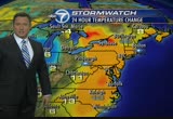
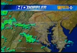
garrett county, western maryland. frostburg has snow on the ground. parts of eastern and southern west virginia. all this area in white on storm team 4 radar. meanwhile farther east in the form of rain. getting a few moderate views in washington. these areas in yellow and orange and fairfax county. just to the west of 95 down to prince william county. farther west, a couple of pockets of moderate showers in loudoun county. these are all just rotating around the general large circulation of what was sandy, now a post-tropical low that is now inland. it is a chilly morning. temperatures only in the low to mid-40s much of the region. reagan national is at 44. meanwhile, out of the west where they're getting that snow, many locations just in the 30s. the high elevations around 2,000 feet are freezing. martinsburg and augusta, 43. we also have flood warnings in effect until 5:45. many creeks and streams will be out of their banks through much of the region. blizzard warnings in effect for these counties. generally above 5,000 feet, up to a foot of snow the
garrett county, western maryland. frostburg has snow on the ground. parts of eastern and southern west virginia. all this area in white on storm team 4 radar. meanwhile farther east in the form of rain. getting a few moderate views in washington. these areas in yellow and orange and fairfax county. just to the west of 95 down to prince william county. farther west, a couple of pockets of moderate showers in loudoun county. these are all just rotating around the general large circulation of what...
255
255
Oct 1, 2012
10/12
by
WJLA
tv
eye 255
favorite 0
quote 0
fog this morning across western of maryland and northern virginia. just some areas of dense fog where it could be under a quarter mile visibility. seeing that in fairfax as well. yourself extra time. jacket this morning in the district at 54 degrees. 50 at bwi, 48 in manassas, 45 in cumberland. we will get to the low 70's today with clouds increasing day.gh the showers late, but dry.of the day will be we are optimistic. head over to traffic with angela. no early issues to contend terms of accidents. we are dealing with reduced visibility on the roads. but we are getting the traffic cones out of the way. overnight construction listed 3995 in virginia as well as beltway, will be quite well from the springfield interchange, the inner loop pretty good to on gallows road area, also reported loop, no trouble crossing the woodrow wilson bridge. trek in maryland's around the capital beltway, even andretty good around the northwest branch region. overnight construction is gone. there's a traffic pattern with ongoing work, but not causing -- earlyer delays del
fog this morning across western of maryland and northern virginia. just some areas of dense fog where it could be under a quarter mile visibility. seeing that in fairfax as well. yourself extra time. jacket this morning in the district at 54 degrees. 50 at bwi, 48 in manassas, 45 in cumberland. we will get to the low 70's today with clouds increasing day.gh the showers late, but dry.of the day will be we are optimistic. head over to traffic with angela. no early issues to contend terms of...
391
391
Oct 29, 2012
10/12
by
WBAL
tv
eye 391
favorite 0
quote 0
blizzard warnings are in effect in western maryland. up to a foot of snow in garrett county with winds up to 40. 18-mile-per-hour gusts at the airport. they will pick up this afternoon. the worst part of the winds for baltimore will be this afternoon anything. for folks on the western shore of the day, a blowout winds. when the high tides come in on the shore this one, you guys will not have a problem, but on the eastern shore, your high tights might come in one to three feet above average. that is not a storm surge, that is only because of the wind direction. twitter 50 mi. east, southeast of ocean city, that was -- 250 miles east, southeast of ocean city, and i was beginning to turn it is losing its tropical characteristics, but it is getting a stronger. it is passed the mouth of the chesapeake bay, so we can take the worst-case scenario of the table of this turning and going across the chesapeake bay, with this will it hit new jersey and hit it hard. this next the hard left turn by 6:00. comes onshore and it will be even stronger. i
blizzard warnings are in effect in western maryland. up to a foot of snow in garrett county with winds up to 40. 18-mile-per-hour gusts at the airport. they will pick up this afternoon. the worst part of the winds for baltimore will be this afternoon anything. for folks on the western shore of the day, a blowout winds. when the high tides come in on the shore this one, you guys will not have a problem, but on the eastern shore, your high tights might come in one to three feet above average....
149
149
Oct 23, 2012
10/12
by
WBAL
tv
eye 149
favorite 0
quote 0
maybe a sprinkle of rain or too up in western pennsylvania and amounts of western maryland. the first high, thin clouds break east of the mountains for baltimore in the morning. 53 downtown, high pressure off the carolinas will be moving away from us and opening the door to mild air in the tennessee and ohio valley. 74 degrees in kansas city and 63 in chicago. cliveden right now at 67, unusually warm temperatures for this time of october. most of this week we stay on the warm side of assistance. partly cloudy skies in the morning to mostly cloudy at times. the cloud cover will hold down the temperature. the same thing on wednesday, a mix of clouds and sunshine with the potential to see temperatures pushing into the upper 70's. by thursday, we should see more sunshine and the temperature staying above normal. 73-78 tomorrow, southwest winds at 5 miles an hour. waves around 1 foot on the bay. it could push close to 70 on wednesday with part a cloudy skies. eastern shore locations, unseasonably mild weather. sprinkle that near cecil county come otherwise dry. on the lower easte
maybe a sprinkle of rain or too up in western pennsylvania and amounts of western maryland. the first high, thin clouds break east of the mountains for baltimore in the morning. 53 downtown, high pressure off the carolinas will be moving away from us and opening the door to mild air in the tennessee and ohio valley. 74 degrees in kansas city and 63 in chicago. cliveden right now at 67, unusually warm temperatures for this time of october. most of this week we stay on the warm side of...
208
208
Oct 30, 2012
10/12
by
WBAL
tv
eye 208
favorite 0
quote 0
reports of upwards of 30 inches of snow from western maryland down for west virginia. the ski resorts are happy, but the power lines are taking the brunt of that early snow. hagerstown now dropped to 39 degrees. higher yields in baltimore, carroll county in frederick county, back for the mountains, are most prone to see a little bit of wet snow mixing in overnight. 35-41 for the low and south winds at 5-10. down at the inner harbor, the water has not dropped much from the high tide this morning. the next tide is going to roll in on top of that. annapolis at about 6:30, and up to the top of the day at almost 11:00 tonight. they will be anywhere from 2 feet to 4 feet, may be up to 5 feet above normal in spots. the potential is there for some flooding over night from the tides. more snow in the mounds through tomorrow and even into thursday they will still get a little bit of snow. east of the mountains, this clouds will start to break up and by friday and into the weekend, we should get a decent clearing trend. the forecast calls for temperatures to be chilly, showers en
reports of upwards of 30 inches of snow from western maryland down for west virginia. the ski resorts are happy, but the power lines are taking the brunt of that early snow. hagerstown now dropped to 39 degrees. higher yields in baltimore, carroll county in frederick county, back for the mountains, are most prone to see a little bit of wet snow mixing in overnight. 35-41 for the low and south winds at 5-10. down at the inner harbor, the water has not dropped much from the high tide this...
202
202
Oct 22, 2012
10/12
by
WBAL
tv
eye 202
favorite 0
quote 0
western maryland, high temperatures in the mid-60's, and that is mild for this time of the year. eastern shore locations, 70 tomorrow and nearer 80 wednesday. on the lower eastern shore including ocean city, temperatures will look into the 70's with partly cloudy skies. we have had to make systems pop up today, the 18th possible depression of the season became sandy. the other one is way out in the atlantic, expected to become tropical storm tony. that one is expected to stay way out in the atlantic. mid-70's tomorrow, upper 7's wednesday. a chance for rain over the weekend. >> time is running out for homeowners to apply for continued homestead tax credit benefits. that is a tax credit maryland homeowners are required to apply for. city officials want to make sure everyone is aware that the deadline to apply for the credit is december 31. if you have been receiving homestead tax credit, you have to reapply. for more information on how to do that, go to our website, wbaltv.com. we also have a live report on this coming up tonight at 6:00. a financial plan to help people stay in th
western maryland, high temperatures in the mid-60's, and that is mild for this time of the year. eastern shore locations, 70 tomorrow and nearer 80 wednesday. on the lower eastern shore including ocean city, temperatures will look into the 70's with partly cloudy skies. we have had to make systems pop up today, the 18th possible depression of the season became sandy. the other one is way out in the atlantic, expected to become tropical storm tony. that one is expected to stay way out in the...
167
167
Oct 19, 2012
10/12
by
WRC
tv
eye 167
favorite 0
quote 0
west virginia and western maryland still a few lingering showers there. and temperatures, all the areas in light green in the bal mchl y 60s. points west and north in the 50s. out of the mountains, it's in the 40s. here is the storm team 4 four-day forecast. enjoy a wonderful pattern into the weekend. by this afternoon, we'll dry out with sunshine and into the mid-70s. overnight tonight, we're heading out. down to near 60 at midnight under a clearing sky and upper 40s by dawn on saturday. bit of a chilly start tomorrow morning. then on saturday, partly cloudy. we should climb into the mid-60s. a delightful day for outdoor activities. as we get into sunday, afternoon saturday night's clear sky. it's going to get cold saturday morning, down near 40. warming into the mid-60s with the bright sun on sunday afternoon. another delightful day for outdoor activities on sunday. monday, back to work and school. low 40s again, but warmer during the afternoon. with bright sunshine, monday, up near 70. then even a bit milder as we get into next week. tuesday, wednesday
west virginia and western maryland still a few lingering showers there. and temperatures, all the areas in light green in the bal mchl y 60s. points west and north in the 50s. out of the mountains, it's in the 40s. here is the storm team 4 four-day forecast. enjoy a wonderful pattern into the weekend. by this afternoon, we'll dry out with sunshine and into the mid-70s. overnight tonight, we're heading out. down to near 60 at midnight under a clearing sky and upper 40s by dawn on saturday. bit...
202
202
Oct 29, 2012
10/12
by
WBAL
tv
eye 202
favorite 0
quote 0
blizzard warnings are in effect in western maryland. they will get a lot of snow there and we may get a few flakes in baltimore tuesday in the cold air. today rain heavy and flooding likely. maybe up to eight inches in some areas. maybe more than that on the eastern shore. gusts 20 to 30 miles an hour this morning up to 60 this evening and tonight. then the cold air comes in. highs only in the 40's tomorrow. it will be snowing in the mountains. there could be a few flakes around baltimore. halloween there could be a few leftover showers but it should be better with a high near 50. then we get to rest over the weekend. >> it is 6:53 and 52 degrees. >> still ahead we will look at weather and weather and more weather. here is a live look from along the slowerline near boston, massachusetts. back in a moment. it's oysternomics 101. you start with a u.s. senator named ben. by helping restore thousands of acres of oyster beds, he kept hundreds of oystermen on the job... which keeps wholesalers in business... and that means more delivery compa
blizzard warnings are in effect in western maryland. they will get a lot of snow there and we may get a few flakes in baltimore tuesday in the cold air. today rain heavy and flooding likely. maybe up to eight inches in some areas. maybe more than that on the eastern shore. gusts 20 to 30 miles an hour this morning up to 60 this evening and tonight. then the cold air comes in. highs only in the 40's tomorrow. it will be snowing in the mountains. there could be a few flakes around baltimore....
147
147
Oct 16, 2012
10/12
by
WRC
tv
eye 147
favorite 0
quote 0
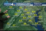
that includes much of western -- parts of western maryland, highlands of west virginia. in green, those are areas in the low 50s. reagan national at 54. we're going to stay chilly this morning with winds gusting 15, 20 miles an hour. not much of a warmup in the morning hours. by 6:00 a.m., upper 40s. which midafternoon with the sunshine, ought to make it to upper 60s. winds still a bit gusty. sunrise 7:19. sunset 6:28. i'm back with a hometown forecast in ten minutes. your first 4 traffic on this tuesday morning with danella. >>> traveling the roadways, you know what time it is, road work. wrapping up in the area, but still some places have road work. in you're traveling the inner loop and outer loop in montgomery county, the same road work is there. it is along the left side. travel lanes are open. volume very light. so it's not any delays as you approach the road work there. traveling i-270 northbound at 80, finger board road there, road work also blocks the left lane and shoulder lane as you make your way northbound. travel lanes are open. a live look as you make your
that includes much of western -- parts of western maryland, highlands of west virginia. in green, those are areas in the low 50s. reagan national at 54. we're going to stay chilly this morning with winds gusting 15, 20 miles an hour. not much of a warmup in the morning hours. by 6:00 a.m., upper 40s. which midafternoon with the sunshine, ought to make it to upper 60s. winds still a bit gusty. sunrise 7:19. sunset 6:28. i'm back with a hometown forecast in ten minutes. your first 4 traffic on...
217
217
Oct 19, 2012
10/12
by
WRC
tv
eye 217
favorite 0
quote 0
few passing showers still out in the western mountains of western maryland and eastern west virginia where temperatures there and this blue zone are in the 40s. all the areas in green are in the 50s and 60s. right around 60 degrees in the suburbs in washington right now. reagan national at 66. for the morning commute, you may need an umbrella. just a small chance of a passing light shower. sunrise at 7:22. we'll be in the low 60s or so for another couple of hours. by noontime for your lunch hour, climbing up to around 70 and sunshine breaking out. we'll get increasing sun during the afternoon. by late afternoon, after we reach the mid-70s midafternoon, back down to near 70 by 6:00 p.m. clearing, mild, southwesterly breezes will shift into the northwest overnight and a nice evening. here's your evening planner for this friday evening. by midnight under a clear sky, back down near 60. by dawn on saturday, the upper 40s. beautiful day tomorrow for outdoor activities. partly cloudy, into the mid-60s during the afternoon. really chilly sunday morning. down around 40. by sunday afternoon,
few passing showers still out in the western mountains of western maryland and eastern west virginia where temperatures there and this blue zone are in the 40s. all the areas in green are in the 50s and 60s. right around 60 degrees in the suburbs in washington right now. reagan national at 66. for the morning commute, you may need an umbrella. just a small chance of a passing light shower. sunrise at 7:22. we'll be in the low 60s or so for another couple of hours. by noontime for your lunch...
198
198
Oct 25, 2012
10/12
by
WBAL
tv
eye 198
favorite 0
quote 0
. >> one of those days in maryland where the western maryland mountains ended up warmer than central and eastern parts of the state because of the cloud cover their role in of the ocean. temperatures were held in check around baltimore and down to the coast, while in the mountains, temperatures in the seven's and even the 80's. "net 72, but only 67 at bwi marshall. the clouds and fog will thicken up. may briefly cleared out early this evening in spots and then it will feel back in when they redevelop. we still have the east wind supplying the moisture from the ocean. the weather pattern will be energized by a strong cold front. 28 in denver right now, and 72 in kansas city. that front is moving east and it will combine with sandy coming up from the bahamas. where they collide, that is where we will get a really energized storm. it will be important to see where sandy goes as it moves up the coast and the timing of this front coming in from the west. it looks like the front go through here saturday night and sunday morning, and sandy will be coming in sunday night into monday. the eye
. >> one of those days in maryland where the western maryland mountains ended up warmer than central and eastern parts of the state because of the cloud cover their role in of the ocean. temperatures were held in check around baltimore and down to the coast, while in the mountains, temperatures in the seven's and even the 80's. "net 72, but only 67 at bwi marshall. the clouds and fog will thicken up. may briefly cleared out early this evening in spots and then it will feel back in...
209
209
Oct 29, 2012
10/12
by
WMAR
tv
eye 209
favorite 0
quote 0
we are going to be dealing with some snow in western maryland as well. and our viewing area the snow will stay away from us. but this is what we are looking out in terms of rainfall when it's all said and done up to 6 to 8 inches of rain across the area. and also with this storm, we are going to be dealing with some very windy conditions tropical storm force winds as we go throughout the day and also along delaware up towards the north we are going to be dealing with hurricane-force winds as we go through the remainder of today and tomorrow. let's check the abc2 timesaver traffic with lauren cook. good morning. >> reporter: good morning. mta service has been suspended until further notice. and governor ohaly is asking everyone -- o'malley is asking everyone to stay at home. conditions are bad. especially on the eastern shore. route 50 is going to be shut down heading into ocean city. that is live look at the draw big. notice the camera shaking. there's a win feck for the key bridge and by a -- there's -- many roads are shut down in anticipation of heavy
we are going to be dealing with some snow in western maryland as well. and our viewing area the snow will stay away from us. but this is what we are looking out in terms of rainfall when it's all said and done up to 6 to 8 inches of rain across the area. and also with this storm, we are going to be dealing with some very windy conditions tropical storm force winds as we go throughout the day and also along delaware up towards the north we are going to be dealing with hurricane-force winds as we...
 Live Music Archive
 Librivox Free Audio
 Metropolitan Museum
 Cleveland Museum of Art
 Internet Arcade
 Console Living Room
 Books to Borrow
 Open Library
 TV News
 Understanding 9/11